
Canada Fall Colors Map: Nova Scotia's Week-by-Week Peak Colour
Seven foliage regions · Week-by-week peak grid · Schematic map · Canada-wide context
Nova Scotia's fall foliage season sweeps across seven distinct regions between late September and late October, and timing is everything. This map-driven companion to our complete fall foliage guide pairs every region's typical peak window - computed from the same regional dataset - with a full fall season hub of festivals, harvest trips, and accommodation advice. Canada's foliage sweep begins in the northern boreal forest in early September and reaches the Atlantic provinces last, and most cross-border leaf-peepers searching a fall foliage map for Canada land here - in the Maritimes' most complete foliage breakdown, where the Cabot Trail's highland colour runs about two weeks ahead of the South Shore's coastal mix. Start with the at-a-glance table, confirm your week in the grid, then use the schematic map to plan the drive. For broader trip framing, see Nova Scotia in October or our best-time-to-visit tool.
Peak Windows at a Glance
Typical peak colour windows for all seven foliage regions, derived from the same dataset that drives the map. The status column is set from each region's window at publish time and refreshes live in your browser.
| Region | Typical peak | Status today | Plan with |
|---|---|---|---|
| Cape Breton Highlands & Cabot Trail | October 1–15 | Past peak | Full foliage-by-region notes |
| Northumberland Shore (Sunrise Trail) | October 5–15 | Past peak | Full foliage-by-region notes |
| Bay of Fundy & Annapolis Valley | October 5–20 | Past peak | Full foliage-by-region notes |
| South Shore & Lunenburg | October 10–25 | Past peak | Full foliage-by-region notes |
| Halifax Metro | October 12–28 | Past peak | Full foliage-by-region notes |
| Eastern Shore (Marine Drive) | October 14–30 | Past peak | Full foliage-by-region notes |
| Yarmouth & Acadian Shores | October 15–30 | Past peak | Full foliage-by-region notes |
Regional windows are typical ranges, not forecasts. Coastal fog and elevation can move a region's colour by up to a week.
Canada Fall Colors Map: When Each Region Peaks
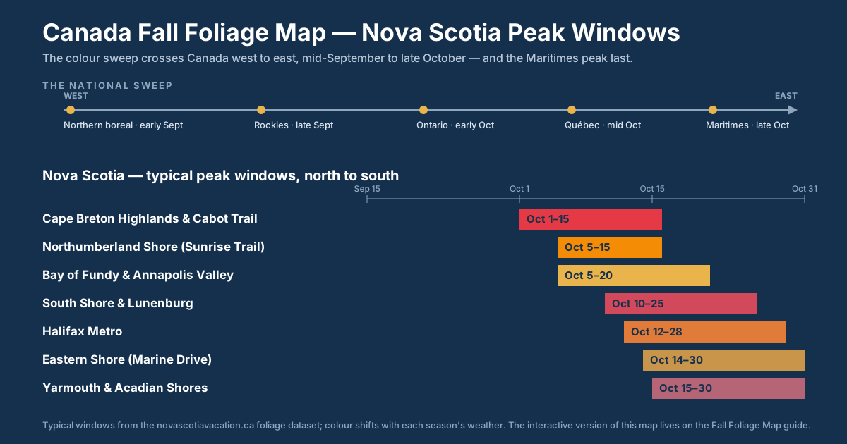
The national answer in one line: colour sweeps Canada over roughly eight weeks, opening in the northern boreal forest in early September and finishing in the Maritimes in late October - the last region of the country to peak. The static Canada fall foliage map above frames that national picture, and the table below places the seven provincial windows above in the national sequence: colour starts in the northern boreal forest, moves through the Rockies and Central Canada, and finishes in the Maritimes. Cross-country leaf peepers can work west to east and chase fresh colour for roughly eight weeks, landing in Nova Scotia when every other region has already turned.
| Region | Colour starts | Typical peak | Why it differs |
|---|---|---|---|
| Northern boreal forest (Yukon, NWT, northern Manitoba, Ontario, and Québec) | Early September | Early to mid September | Shortest season in the country - aspens and birches turn quickly after the first frost |
| Rocky Mountains (Banff and Jasper) | Mid September | Late September | Golden larches at elevation; conifers hold the rest of the range green |
| Ontario (Algonquin and Muskoka) | Late September | Late September to mid October | Sugar maple heartland with intense, widespread colour |
| Québec (Laurentides and Charlevoix) | Late September | Early to mid October | Maple corridors north of the St. Lawrence mirror Ontario a few days later |
| Maritimes (New Brunswick, PEI, and Nova Scotia) | Late September - Cape Breton Highlands first | Early to late October | Ocean-moderated and last in Canada to peak; the Nova Scotia windows above come from this page's own dataset |
For provinces and territories not named in a row above - southern Manitoba and Saskatchewan, interior and coastal British Columbia, and Newfoundland and Labrador - the same west-to-east progression applies without a single fixed window; regional parks and tourism sources confirm local conditions through the season.
The Atlantic depth on this page is where the map earns its keep. Within the Maritimes' early-to-late October window, Nova Scotia's seven foliage regions peak in sequence - the Cape Breton Highlands first, the Yarmouth and Acadian Shores last - and two signature drives bookend that sequence: the Cabot Trail around the earliest-peaking highlands and the Lighthouse Route along the later-turning South Shore, both cross-referenced with peak windows in the scenic drives table below.
Nova Scotia windows are computed from this page's regional dataset; all other windows are typical ranges - confirm current conditions with provincial parks and tourism sources before booking travel.
When Do Leaves Change in Canada? Provincial Timing Grid
Colour crosses the country on a west-to-east tilt, so the same week can mean peak gold in one province and green canopy in another. The grid below lays all ten provinces on one early-September-to-late-October timeline, using the same typical windows as the table above. The Nova Scotia row is highlighted because its seven foliage regions stretch the season from late September to late October - the longest provincial sweep in the country.
| Province | Typical colour window |
|---|---|
| British Columbia | Late September to late October |
| Alberta | Mid September to early October |
| Saskatchewan | Mid September to early October |
| Manitoba | Mid September to early October |
| Ontario | Late September to mid October |
| Québec | Late September to mid October |
| New Brunswick | Early to mid October |
| Prince Edward Island | Early to mid October |
| Nova Scotia | Late September to late October - Cape Breton Highlands first, Yarmouth and Acadian Shores last |
| Newfoundland and Labrador | Early to mid October |
The Schematic Foliage Map
A simplified schematic of Nova Scotia's seven foliage regions - not to scale, positions approximate. Click a region shape to highlight its row in the table above, or use the status filter to see what is peaking right now. Full regional write-ups live in the foliage-by-region section of the main guide.
Week-by-Week Peak Grid
The same seven windows laid out as a season grid. A filled cell means that week overlaps the region's typical peak, so mid-season trips can chase colour across two or three neighbouring regions.
| Region | October 1 | October 8 | October 15 | October 22 | October 29 |
|---|---|---|---|---|---|
| Cape Breton Highlands & Cabot Trail | peak | peak | peak | ||
| Northumberland Shore (Sunrise Trail) | peak | peak | peak | ||
| Bay of Fundy & Annapolis Valley | peak | peak | peak | ||
| South Shore & Lunenburg | peak | peak | peak | ||
| Halifax Metro | peak | peak | peak | ||
| Eastern Shore (Marine Drive) | peak | peak | peak | peak | |
| Yarmouth & Acadian Shores | peak | peak | peak |
Weeks are anchored to the earliest regional start in the dataset and step forward in seven-day increments.
Scenic Drives Cross-Reference
Match the drive to the week. Each route inherits the peak window of its foliage region, so you can slot a signature drive into the exact days your trip is in the province.
| Drive | Region | Typical peak | Route guide |
|---|---|---|---|
| Cabot Trail loop | Cape Breton Highlands & Cabot Trail | October 1–15 | Route guide |
| Sunrise Trail (Pictou to Antigonish) | Northumberland Shore (Sunrise Trail) | October 5–15 | Route guide |
| Evangeline Trail (Wolfville to Digby) | Bay of Fundy & Annapolis Valley | October 5–20 | Route guide |
| Lighthouse Route (Halifax to Liverpool) | South Shore & Lunenburg | October 10–25 | Route guide |
| Marine Drive (Musquodoboit to Sherbrooke) | Eastern Shore (Marine Drive) | October 14–30 | Route guide |
| Peggy's Cove coastal lookoff loop | Halifax Metro | October 12–28 | Route guide |
| Yarmouth & Acadian Shores corridor | Yarmouth & Acadian Shores | October 15–30 | Route guide |
| Kejimkujik interior hardwoods | Bay of Fundy & Annapolis Valley | October 5–20 | Route guide |
Timing by Region
One tight timing note per region. Peak windows are computed from the dataset above; for the full lookoff-by-lookoff treatment, open the companion fall foliage guide.
Cape Breton Highlands & Cabot Trail
Typical peak: October 1–15 - the first region to turn.
Highland elevation makes the Cabot Trail the earliest and most dramatic colour in the province. Pair timing with the Cabot Trail fall colours itinerary and book early - peak weeks coincide with Celtic Colours.
Northumberland Shore (Sunrise Trail)
Typical peak: October 5–15.
The Sunrise Trail turns only days after the highlands, with gentler terrain and quieter roads. Base in Pictou or Antigonish using the Northumberland Shore guide.
Bay of Fundy & Annapolis Valley
Typical peak: October 5–20.
Valley orchards and vineyards layer colour against the Fundy cliffs. The Annapolis Valley self-drive covers the best corridor, with harvest stops from our fall harvest guide.
South Shore & Lunenburg
Typical peak: October 10–25.
Lighthouse Route villages hold colour deep into the season's back half. Combine with Lunenburg's Old Town and the full South Shore guide.
Halifax Metro
Typical peak: October 12–28.
City parks and coastal lookoffs peak mid-window without needing a long drive. Use the Halifax day-trip guide for Peggy's Cove loop timing.
Eastern Shore (Marine Drive)
Typical peak: October 14–30.
The Marine Drive keeps Atlantic views inside a late-peeping forest corridor. Route notes live in the Eastern Shore guide.
Yarmouth & Acadian Shores
Typical peak: October 15–30 - the last region to hold leaves.
The southwest corner stretches the season to its final days. US visitors arriving on the CAT ferry from Bar Harbor land inside this region; see the Acadian Shores guide for loops.
Using the Map to Plan
Chase the sweep, not one date
Colour moves north-to-highlands first, then south and west. A trip placed mid-season can catch the Fundy corridor and the South Shore in the same week - the week grid shows exactly which regions overlap.
Book accommodation around peak
Cabot Trail lodging sells out for the first regional window because it overlaps festival season. The Celtic Colours accommodation guide and where-to-stay guide cover the fallbacks.
Layer for fall weather
Peak weeks run five to fifteen degrees Celsius with fast-changing skies. The weather-by-month guide and packing list keep the drives comfortable.
Photographers: aim early
First and last light do the heavy lifting on colour. The photography guide ranks the lookoffs; the Skyline Trail parking guide covers the sunrise hike.
Fall Foliage Map Questions, Answered
When is peak fall foliage in Nova Scotia? The province-wide season runs from late September through late October. Colour starts in the Cape Breton Highlands and the northern interior first, then sweeps south and west, with the Yarmouth and Acadian Shores and the Eastern Shore holding leaves latest. Each region holds peak colour for roughly ten days to two weeks, so the tables and schematic map on this page let you line up your dates with the right region.
Which part of Nova Scotia peaks first? The Cape Breton Highlands peak first. Cooler highland nights trigger the sugar maples and birches around the Cabot Trail before the rest of the province turns, followed within days by the Northumberland Shore and the Bay of Fundy corridor. The South Shore, Halifax, Eastern Shore, and the Acadian Shores round out the season in the final two weeks of October.
Is the Cabot Trail the best drive for fall colors? For many travellers, yes - the Cabot Trail is the marquee fall colors drive in Atlantic Canada, with ocean-to-highland lookoffs where hardwood colour drops straight into the sea. It also peaks earliest in the province, so book accommodation early. That said, the Lighthouse Route and the Evangeline Trail deliver comparable colour with lighter traffic if your trip lands in the back half of October.
When do leaves change colour in Canada? The national season runs roughly eight weeks, moving from the northern boreal forest in early September, through the Rockies in late September and Central Canada from late September into mid October, and finishing in the Maritimes, which hold colour into late October. Nova Scotia sits at the end of that sweep, which is why the provincial season stretches later than anywhere else in the country.
Is there a fall colors map for all of Canada? There is no single official real-time map covering all of Canada. Federal and provincial parks and tourism agencies post regional fall colour updates through the season. This page covers the Atlantic end: the week-by-week grid and schematic map above detail the seven Nova Scotia foliage regions, and the table above sets typical windows for the rest of the country.
Where can I see a Canada fall colors map week by week? No single official source publishes a week-by-week Canada fall colors map. For the Atlantic end, the week-by-week peak grid higher up this page breaks the season into dated weeks for all seven Nova Scotia foliage regions, and the Canada table above sets the typical window for each region of the country. Provincial parks and tourism agencies post in-season updates for the rest of the country.
What is the best week for fall colours in Atlantic Canada? The Atlantic window runs early to late October. New Brunswick, PEI, and Nova Scotia share that sweep, with Nova Scotia’s Cape Breton Highlands turning first and the South Shore, Eastern Shore, and Acadian Shores holding colour into the final week. Mid-October is the safest single week to catch multiple regions at once - the week-by-week grid above shows which regions are in window for any week you are considering.
When does foliage season end in Nova Scotia? By early November, wind and rain have stripped most regions, starting with the highlands and finishing along the southwest coast. Late-October visitors get the tail end of colour plus pumpkin patches and harvest events. If your trip slides past the season, the November guide covers what the province does well once the leaves are down.
Is there a Canada fall foliage map for 2026? Foliage timing follows the same typical windows every year - weather shifts each province’s peak by a few days, not weeks, so a 2026 trip plans out like any other season. Use the provincial timing grid above to see when leaves change in each province, then narrow your dates with the week-by-week peak grid for Nova Scotia’s seven foliage regions.
Where can I find a fall colour map of Canada? There is no single official real-time fall colour map covering all of Canada. This page covers the Atlantic end with its own dataset - the provincial timing grid, the week-by-week grid, and the schematic map above detail Nova Scotia’s seven foliage regions. For the rest of the country, provincial parks and tourism agencies post in-season colour updates.
Is there a Nova Scotia foliage map? Yes - this page is one. The schematic map lays out the seven foliage regions, the week-by-week grid shows each region’s typical peak window, and the peak windows table includes a live status column that refreshes in your browser through the season.