Nova Scotia Map: Regions, Routes & Printable Map of Nova Scotia, Canada
See where everything is before you plan - all eight travel regions, the Cabot Trail, the Lighthouse Route and the Bay of Fundy tide line on one interactive map.
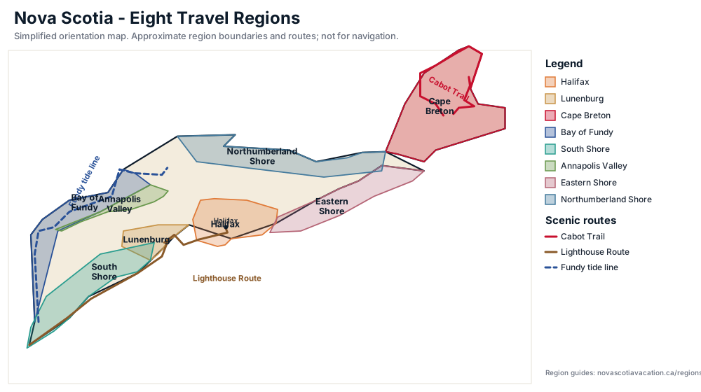
Nova Scotia - Latin for New Scotland - is a peninsula of roughly 55,000 square kilometres (with 13,300 kilometres of coastline) on Canada's Atlantic coast - small enough to drive across in a day, but with the eight distinct travel regions on this map that reward a little orientation. This map shows the whole province with each region colour-coded, so you can see at a glance how Halifax relates to the South Shore, where the Annapolis Valley meets the Bay of Fundy, and how far Cape Breton sits from everything else.
Use the checkboxes beside the map to layer on three of the province's signature drives: the Cabot Trail loop around northern Cape Breton, the Lighthouse Route from Halifax to Yarmouth (with markers for more than 180 lighthouses), and the Bay of Fundy tide line along the world's highest tides. Hover or tap any region polygon for its name, then follow the links in the regions table below for full guides to each area.
Prefer paper? Scroll down for a simplified printable map you can download and fold into the glovebox - handy where cell coverage thins out along the Cabot Trail and the Eastern Shore. For routing between regions see our road trip planner and the fall foliage map.
Interactive map of Nova Scotia, Canada

Scenic route overlays
Tap or hover a region for its name. The map loads when you scroll to it.
Cape Breton Island map
Cape Breton Island sits at the top of the Nova Scotia map, an island joined to the mainland by the Canso Causeway at Port Hastings. It is the only one of the province's eight travel regions on an island - which is exactly why it deserves its own map. Cross the causeway and the scale changes: the Cape Breton Highlands rise along the island's northwest shoulder, the Bras d'Or Lake - an inland sea - threads through its centre, and Sydney anchors the east coast. The focused map below zooms in on the island with the Cabot Trail traced and eight pins marking the places travellers plan trips around. For the wider picture, our Cape Breton region guide covers the island's towns, drives and culture in depth.
The highlighted loop is the Cabot Trail, the roughly 300-kilometre scenic drive that circles the northern Highlands and routinely ranks among the greatest on the continent. The pins mark its practical anchors: Baddeck, the trailhead town on the shore of the Bras d'Or Lake; Ingonish in the east and Chéticamp in the west, the two gateways to Cape Breton Highlands National Park; Meat Cove, the rugged fishing cove at the trail's northern tip; and Margaree Harbour, where the loop meets the Ceilidh Trail on the west coast. Farther south, Sydney and Louisbourg pin the island's industrial and military past. Timing a foliage trip? Our Cabot Trail fall colours guide breaks the loop down day by day.
Driving the loop itself takes about five hours behind the wheel, but most travellers budget a full day or two for look-offs, hikes and lobster rolls - the whole point of the drive is slowing down. Flying into Sydney or stepping off the Newfoundland ferry at North Sydney? Baddeck is about an hour's drive from either, which makes it the classic first night on the trail and the natural place to start the loop clockwise. The Cabot Trail layer is already switched on in the map below, so you can trace every pin against the road before committing to an itinerary.
Cape Breton overlays
The map loads when you scroll to it.
The eight regions on our Nova Scotia map
Every region on the map has its own guide - use this table to jump straight to the area you are researching.
| Region | Where it is & what it's known for |
|---|---|
| Halifax | The provincial capital and most common arrival point, with the historic waterfront, the Citadel, and Peggy's Cove within day-trip range. |
| Lunenburg | The UNESCO World Heritage town at the heart of the South Shore's fishing-village coast, near Mahone Bay and Chester. |
| Cape Breton | The island north of the Canso Causeway, home to the Cabot Trail, the Highlands, and Cape Breton Highlands National Park. |
| Bay of Fundy | The Fundy shore from Digby to Advocate Harbour, where the world's highest tides reshape the coastline every day. |
| South Shore | Lighthouse country from Yarmouth to Liverpool - fishing villages, white-sand beaches, and the Lighthouse Route drive. |
| Annapolis Valley | Wine country and orchards between the mountains, running from Annapolis Royal through Kentville to Wolfville and Grand Pré. |
| Eastern Shore | The wild Atlantic coast east of Halifax - surf beaches, rugged islands, and quiet fishing communities. |
| Northumberland Shore | The warm-water Northumberland Strait coast facing Prince Edward Island, from Amherst past Pictou to Antigonish. |
New to the province? Start with the plan your trip hub or the fall foliage map.
Printable map of Nova Scotia
The same regions and routes as a simplified one-page map - handy for the glovebox where cell coverage thins out on the Cabot Trail and the Eastern Shore. Download it, or print this page (the map below prints with it). For the national picture, our Canada fall foliage map times the colour sweep from the northern boreal forest to the Maritimes.
Nova Scotia map questions, answered
Where is Nova Scotia on a map? Nova Scotia is a peninsula on Canada's Atlantic coast, almost completely surrounded by the sea. It sits southeast of New Brunswick (connected by the Chignecto Isthmus), south of Prince Edward Island across the Northumberland Strait, and southwest of Newfoundland. From Halifax it is roughly a 3.5-hour ferry ride to Bar Harbor, Maine and a 12-hour drive to Boston via New Brunswick and Maine.
What are the regions of Nova Scotia? Nova Scotia's official tourism site organizes the province into seven regions. Travellers and most guides - including this map - usually work with eight: Halifax, the South Shore, Lunenburg, the Annapolis Valley, the Bay of Fundy shore, the Eastern Shore, the Northumberland Shore, and Cape Breton Island. Each region on the interactive map above is colour-coded, and the table below links to a full guide for every one of them.
How long is the Cabot Trail? The Cabot Trail is a scenic loop of roughly 300 kilometres around northern Cape Breton Island. Driving it non-stop takes about 5 hours, but most travellers budget a full day or two so they can stop at look-offs, hike in Cape Breton Highlands National Park, and explore villages like Chéticamp and Ingonish. Toggle the Cabot Trail overlay on the map above to trace the route.
Where is the Bay of Fundy? The Bay of Fundy lies along Nova Scotia's northwest shore, separating the province from New Brunswick. On our map it runs from Yarmouth and Digby northeast to Advocate Harbour and the Minas Basin near Parrsboro. The Fundy shore is famous for the world's highest tides - up to 16 metres at Burntcoat Head - and you can see the tide line traced in blue on the map overlay.
What is the Lighthouse Route? The Lighthouse Route is the roughly 300-kilometre stretch of coast (Route 3 alongside Highway 103) between Halifax and Yarmouth, named for the concentration of lighthouses along the way - including Peggy's Cove, Lunenburg, Liverpool's Fort Point, and Cape Forchu. Turn on the Lighthouse Route overlay on the map to see the road itself plus markers for more than 180 Nova Scotia lighthouses.
Where is Peggy's Cove on the map? Peggy's Cove sits about 43 kilometres (a 45-minute drive) southwest of Halifax, on the eastern shore of St. Margarets Bay. It falls inside the Halifax region on our map - the orange polygon southwest of the city - and it is the first famous stop on the Lighthouse Route.
How far is Halifax from the Bay of Fundy? Halifax is roughly 100 kilometres from the Fundy shore at Wolfville and the Annapolis Valley - about an hour and 20 minutes of driving. The Digby side of the Fundy shore is about 3 hours from Halifax, and Advocate Harbour at the eastern end is roughly 3 hours 20 minutes.
Do I need a paper map in Nova Scotia? Cell coverage is good along the main highways (the 100-series and the Trans-Canada), but it drops out on the Cabot Trail's highland sections, the Eastern Shore, and parts of Digby Neck, so a paper map or offline maps are worth carrying outside the cities. Download the printable Nova Scotia regions map below, or pick up the free provincial highway map at any Visitor Information Centre.
How big is Nova Scotia? Roughly 55,284 square kilometres (21,345 square miles), roughly the size of West Virginia or one-third the size of England. It is the second-smallest province in Canada, but its 13,300 kilometres of coastline mean nowhere in the province is more than about 60 kilometres from the sea.
How long does it take to drive around Nova Scotia? A full loop of the classic driving route - Halifax, the South Shore to Yarmouth, up the Fundy shore to Digby and Wolfville, over to Cape Breton and the Cabot Trail, then back to Halifax - is about 1,400 kilometres and 18 hours behind the wheel, which most travellers spread over 7 to 10 days. The bare highway loop without the Cabot Trail is closer to 1,000 km. For day-by-day routing, see our road trip planner link below.
What does Nova Scotia mean? Nova Scotia is Latin for 'New Scotland'. The name was given by Sir William Alexander of Menstrie, a Scottish courtier who received a royal charter from King James VI and I in 1621 to found a Scottish colony in North America. The settlement attempts failed, but the name stayed on the map.
Why is Nova Scotia called New Scotland? Because of the 1621 royal charter: King James VI and I granted Sir William Alexander the territory to establish a Scottish colony. The first attempted settlement in the early 1620s failed, and the territory returned to France in 1632, but the Latin name survived on maps and was revived in the Confederation era.
What does Nova Scotia mean in English? It means 'New Scotland'. The Scottish roots are still official - the provincial flag carries the Scottish saltire, St. Andrew's cross, as its centrepiece.
Where is Cape Breton Island on a map of Nova Scotia? Cape Breton Island sits at the northeastern top of the Nova Scotia map, joined to the mainland by the Canso Causeway at Port Hastings. It is the island of the province's eight travel regions: Sydney sits on its east coast, the Bras d'Or Lake fills its centre, and the Cape Breton Highlands rise along the northwest. The dedicated Cape Breton map above zooms in on the island with the Cabot Trail traced and eight towns and landmarks pinned.
How long does it take to drive the Cabot Trail? The Cabot Trail is a roughly 300-kilometre loop around northern Cape Breton Island, and driving it non-stop takes about 5 hours. Most travellers budget a full day or two so they can stop at look-offs, hike in Cape Breton Highlands National Park, and explore towns like Baddeck, Chéticamp and Ingonish. Trace the whole route, with a pin on every anchor town, on the Cape Breton map above.
Where does the Cabot Trail start and end? The Cabot Trail is usually described as starting and ending at Baddeck, on the northern shore of the Bras d'Or Lake, where the loop meets the Trans-Canada Highway. In practice you can join the loop anywhere - most travellers start at Baddeck, Chéticamp or Ingonish and drive clockwise so the coastal look-offs stay on the right. Sydney is about an hour's drive from Baddeck if you are arriving from the airport or the ferry.